My witness is the empty sky.
Jack Kerouac
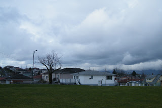
A morning not unlike the many I've followed in the recent past; a light coloured cirrostratus type cover layered the morning sky with several patches of blue peeking through. There were some occasional and bright rays of sun breaking through to the surface in the am, but as the day developed, the sky cover became more intense and the temperature felt as though it took a dive.
In the early afternoon the cloud cover grew darker and much thicker in appearance. Travelling across town to the North Shore, I noticed there were increasingly less breaks in the cloud cover, and the general air of the day became gloomier. The air on the North Shore was biting and felt rather damp.
As the afternoon progressed, the air got colder and more dismal feeling. I suppose the dismal feeling could be more closely related to the fact that the sky became completely over cast and entirely featureless. The cloud cover also appeared lower on the North Shore, but that may just be due to a difference in the perspective. The air seemed still and not particularly damp when I first departed from the North Shore, but around 3pm a light drizzle began to fall. It was a very sparse rainfall, where it seemed as though you could walk between and around individual drops. It was almost like sporadic precipitation, but that is not accurate, because it fell for a good deal of time. The winds also picked up once the rain began to fall, and I felt the wind gust past my house several times throughout the evening. Good ole Vancouver Special construction!
First two photos: facing west, 100% cover nimbostratus clouds @ 5pm
And to the East...what a lovely day!
Whatever Weather, Whenever.
Saturday, March 19, 2011
Part Two: March 17th...
Alas, the skies did not turn green in favour of the day's semi-holiday celebrations.
Today was actually one of the least exciting days to date in this journal.
I didn't do my usual trek across the city to examine all the possible ranges of weather we might be experiencing across the city. From the East side of Vancouver, the skies were grey and white with about an 80% covered sky in the morning, with some cumulus and cirrostratus formations around my home. It was cool and breezy, powerful sunny breaks were appearing through the skies semi-regularly in the morning.
The sky cleared up to about 60% cloud cover through the afternoon and the clouds became a more thin distribution of cirrus 'streets' and wisps. The temperature didn't feel warm, but as compared to the last few days, there was a lot more sunshine occurring through out the day.
In the evening, the sky stayed somewhat clear, and before I went to bed I saw a nice halo around the moon and a dusting of clouds throughout the sky.
Facing West at around 5:30pm
Facing East, same time. 75% cloud cover
Readings for the day:
a series of short seasonal summaries: Part one.
Bad blogger! BAD!
doing this on the day of was kinda the whole idea, but hey, life happens.
March 16:
Had a cigarette outside in the morning, and the smoke seemed to sink very still-like into the surrounding air. It seemed to hover and track slowly away from me rather than quickly blowing off into the distance to be absorbed through the atmosphere's volume. I could see my breath, complete with all of it's individual water droplets when I stood perpendicular to the sun ray shining on my patio.
At around 10:30 am, the sky was approximately 80% cloud covered. I couldn't see the clouds moving rapidly as before, but there were some slow changes happening through the sky is you examined a section and then returned to it a few minutes later. The air was cool, with a breeze, and occasionally more robust gusts were blowing by. The open windows in the cloud cover showed beautiful pale blue skies; these tiny reminders of a possible spring time were appearing through altocirrus and cumulus clouds. The clouds throughout the horizon seemed to be sitting at mid to low levels.
1:00 on the North Shore, skies looked much the same, but a little darker and with a greater proportion of cumulus type clouds. The temperature seemed lower, and the occasional breezes were much sharper: they were blowing more quickly and at greater speeds. One of my classmates announced that it had just hailed very briefly on her way into class. The 'storm' happened suddenly, and ended just as quickly.
Leaving the North Shore, there was a huge open section of the sky primarily over the water. Stretches of altocirrus clouds fanned over this window and lower, very dense cumulus clouds were forming under that layer. The sun was more prevalent with this large section of open sky, but it was still pretty cold and breezy.
Both of these photos were taken facing West at about 10 am.
Aaaand the final two are facing East. Wide variety!
Unfortunately (REALLY unfortunately) This has been the most active weather day on my journal, and it also happens to be the day where in I forgot to copy and paste a few surface maps from over the length of the day. Lame. So, I'm trying to pull together some other info that will better help me fully explain the variety of occurrences over the day.
doing this on the day of was kinda the whole idea, but hey, life happens.
March 16:
Had a cigarette outside in the morning, and the smoke seemed to sink very still-like into the surrounding air. It seemed to hover and track slowly away from me rather than quickly blowing off into the distance to be absorbed through the atmosphere's volume. I could see my breath, complete with all of it's individual water droplets when I stood perpendicular to the sun ray shining on my patio.
At around 10:30 am, the sky was approximately 80% cloud covered. I couldn't see the clouds moving rapidly as before, but there were some slow changes happening through the sky is you examined a section and then returned to it a few minutes later. The air was cool, with a breeze, and occasionally more robust gusts were blowing by. The open windows in the cloud cover showed beautiful pale blue skies; these tiny reminders of a possible spring time were appearing through altocirrus and cumulus clouds. The clouds throughout the horizon seemed to be sitting at mid to low levels.
1:00 on the North Shore, skies looked much the same, but a little darker and with a greater proportion of cumulus type clouds. The temperature seemed lower, and the occasional breezes were much sharper: they were blowing more quickly and at greater speeds. One of my classmates announced that it had just hailed very briefly on her way into class. The 'storm' happened suddenly, and ended just as quickly.
Leaving the North Shore, there was a huge open section of the sky primarily over the water. Stretches of altocirrus clouds fanned over this window and lower, very dense cumulus clouds were forming under that layer. The sun was more prevalent with this large section of open sky, but it was still pretty cold and breezy.
Both of these photos were taken facing West at about 10 am.
The clouds formed to the North, 10am ish
Aaaand the final two are facing East. Wide variety!
Unfortunately (REALLY unfortunately) This has been the most active weather day on my journal, and it also happens to be the day where in I forgot to copy and paste a few surface maps from over the length of the day. Lame. So, I'm trying to pull together some other info that will better help me fully explain the variety of occurrences over the day.
Tuesday, March 15, 2011
The Weather Man Wins...
Into each life some rain must fall.
Henry Wadsworth Longfellow
A single glimmering ray of hope was cast upon my front door this morning, as a small window of sunlight glowed through the clouds. For a whole ten seconds I though that the forecast was going to be wrong, that the skies would shortly be cleared away. But as most shining moments of hope, the window closed as quickly as it opened, and was not to be seen again. Rain, rain, and more rain, off and on, all day.
The cloud cover in the morning looked thick and heavy, and far more ominous than one would hope for a week before the spring equinox. The colour and tone of the overhead sky was like that of an all day dawn, wherein the sun chose never to fully arrive. The air was cold, but mostly calm, and on my way to the North Shore I heard birds chirping; a harmony that had been absent, or muffled, for the last few days. Beyond this brief auditory treat, the day revealed itself as "blah,"nothing seemed to be worth much note under the swift moving stratus cover.
On the North Shore, conditions seemed much the same, but the air sputtered with a few more cold breezes. Around 2pm, I noticed rain starting to fall. This rain was the kind where you can feel each individual drop strike your person like a definite, but gentle, tapping on the shoulder. Thick bellowing winds started to rush past around the same time, and small bits of refuse from the surrounding trees and brush were sent skimming through the air. About an hour later the rain had taken on the quality of a steady drizzle: light, but consistent with large slow falling drops.
When I made it back to the East side, the clouds had darkened a few more shades and as soon as I stepped off the bus, I was soaked. The rain drops seemed thinner, but approached with rapid fire. A constant stream of tiny drops rushed down, and I can't say I took a really good look at the sky for the next four blocks as I was foolishly trying to keep dry. Water was running down the streets everywhere I walked, and the worms had come out with it, so I suppose we had met the ground water threshold at this point, around 4pm.
After wringing myself out at home I took another look at the conditions outside; complete cloud cover remained, but the skies had lightened. I imagine that's because the clouds had just dumped all their dark coloured condensation, and there was now an increased amount of 'sunlight' creeping through. The rains continued to start and stop throughout the evening, as did the gusts of wind, and the over all miserable sensation the day had insisted upon conveying.
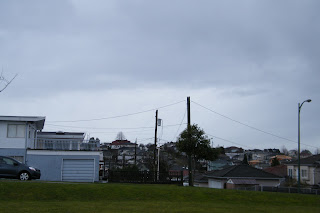
 Facing West: Stratanimbus, Cloud Cover 100%! You can see one rain drop in the corner. I'm an awesome photographer.
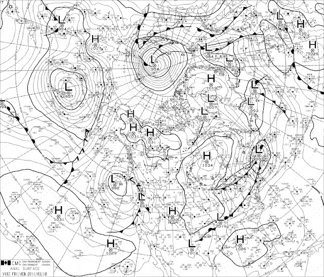
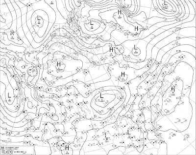
From this surface map you can see Vancouver is sitting in one HUGE low pressure pocket. That means folks, we are most likely in for another deliciously grey day tomorrow. "huurah!"
Henry Wadsworth Longfellow
A single glimmering ray of hope was cast upon my front door this morning, as a small window of sunlight glowed through the clouds. For a whole ten seconds I though that the forecast was going to be wrong, that the skies would shortly be cleared away. But as most shining moments of hope, the window closed as quickly as it opened, and was not to be seen again. Rain, rain, and more rain, off and on, all day.
The cloud cover in the morning looked thick and heavy, and far more ominous than one would hope for a week before the spring equinox. The colour and tone of the overhead sky was like that of an all day dawn, wherein the sun chose never to fully arrive. The air was cold, but mostly calm, and on my way to the North Shore I heard birds chirping; a harmony that had been absent, or muffled, for the last few days. Beyond this brief auditory treat, the day revealed itself as "blah,"nothing seemed to be worth much note under the swift moving stratus cover.
On the North Shore, conditions seemed much the same, but the air sputtered with a few more cold breezes. Around 2pm, I noticed rain starting to fall. This rain was the kind where you can feel each individual drop strike your person like a definite, but gentle, tapping on the shoulder. Thick bellowing winds started to rush past around the same time, and small bits of refuse from the surrounding trees and brush were sent skimming through the air. About an hour later the rain had taken on the quality of a steady drizzle: light, but consistent with large slow falling drops.
When I made it back to the East side, the clouds had darkened a few more shades and as soon as I stepped off the bus, I was soaked. The rain drops seemed thinner, but approached with rapid fire. A constant stream of tiny drops rushed down, and I can't say I took a really good look at the sky for the next four blocks as I was foolishly trying to keep dry. Water was running down the streets everywhere I walked, and the worms had come out with it, so I suppose we had met the ground water threshold at this point, around 4pm.
After wringing myself out at home I took another look at the conditions outside; complete cloud cover remained, but the skies had lightened. I imagine that's because the clouds had just dumped all their dark coloured condensation, and there was now an increased amount of 'sunlight' creeping through. The rains continued to start and stop throughout the evening, as did the gusts of wind, and the over all miserable sensation the day had insisted upon conveying.
 Facing West: Stratanimbus, Cloud Cover 100%! You can see one rain drop in the corner. I'm an awesome photographer.
From this surface map you can see Vancouver is sitting in one HUGE low pressure pocket. That means folks, we are most likely in for another deliciously grey day tomorrow. "huurah!"
Current Conditions
- Observed at:
- Vancouver Int'l Airport
- Date:
- 11:00 PM PDT Tuesday 15 March 2011
- Condition:
- Cloudy
- Pressure:
- 100.3 kPa
- Tendency:
- rising
- Visibility:
- 24 km
- Air Quality Health Index:
- 3
- Temperature:
- 6.7°C
- Dewpoint:
- 5.2°C
- Humidity:
- 90 %
- Wind:
- SE 22 km/h
AAAAAAnd a second reading for the day....
| 15:00 | Light Rain | 10degrees | RH:83 | Td:7 | Wind:ESE 17 | 100.0 kPa |
Monday, March 14, 2011
and the beat goes on...
Well, those rainy sections I predicted didn't come into existence while I travelled across town at all. The day continued on grey and bleak, with thick strataform cloud cover over most of the city. There was a thinning of the clouds, and a brief break through of sunshine while I was on the North Shore around 3:30pm. I could hypothesize that this might have been the result of the warmer air in the occluded front passing over that section of the city, or it may have just been the result of cloud movement related to wind.
When I travelled back across the city, the skies beyond the Vancouver Harbour had puffier, heavy looking cumulous clouds. As I scanned the sky from west to south, thinner cumulous clouds could be seen, but the further south one examined, the more strata/cirrus form the clouds became. It felt cold all afternoon, although warmer than it had felt in the late morning. This could be because the winds seemed to lessen as the day went on, and also simply because the sun had been out longer at that point.
The forecast is stating "rain" pretty much all week, and I hope someone was wrong at the 'weather office,' because I would like to report some more intensive details in the next week besides "strata form!"
All of the following information has been pulled off of Enviro Canada's Weather Office for reference:
- Observed at:
- Vancouver Int'l Airport
- Date:
- 9:00 PM PDT Monday 14 March 2011
- Condition:
- Cloudy
- Pressure:
- 101.4 kPa
- Tendency:
- falling
- Visibility:
- 24 km
-
Issued : 4:00 PM PDT Monday 14 March 2011
- Tonight
- Cloudy. 60 percent chance of showers early this evening. Rain beginning this evening. Amount 10 to 15 mm. Wind southeast 30 km/h except 60 near the Strait of Georgia late this evening and overnight. Low 6.
- Historical Data
- Yesterday
- Max:
- 10.3°C
- Min:
- 5.8°C
- Precip:
- 6.4 mm
- Normals
- Max:
- 10°C
- Min:
- 3°C
- Today
- Sunrise:
- 7:29
- Sunset:
- 19:14
- Temperature:
- 8.8°C
- Dewpoint:
- 5.0°C
- Humidity:
- 77 %
- Wind:
- E 24 km/h

A small observational window
Woke up this morning at nine am to find cold, dreary grey skies abound, and a good gusting of wind out my front door. Throughout the morning burst of rain could be heard pounding the pavement beside my window, and gushes of high winds surfed the channel beside my house and gate.
I walked to the park down the street, which is an awesome spot to survey the cloud cover and formation all over the city. To the NNE, I could see some rain falling from a collection of what I would call cirrostratus clouds, but with the addition of rain, I suppose they would simply be called stratonimbus clouds. The entire sky is cloud covered at the moment, and the clouds coming from the west are textbook altostratus-a darker featurless layer of cloud that looks to be of mid-height classification. Its chilly and a bit windy, and the air felt wet although it wasn't raining at the time. I have a feeling I'm in for sections of rain and cold gusts as I take transit across the city to school.
The weather office provides these readings for the moment:
Taking a look at the currently available surface maps, Vancouver is sitting under a huge low pressure system, and a sizeable occluded front is sitting right over the city.
Cloud Formations visible to the West:
As these layers are "featureless" we have ourselves some stratus clouds!
These far more interesting photos were taken facing NE:

I walked to the park down the street, which is an awesome spot to survey the cloud cover and formation all over the city. To the NNE, I could see some rain falling from a collection of what I would call cirrostratus clouds, but with the addition of rain, I suppose they would simply be called stratonimbus clouds. The entire sky is cloud covered at the moment, and the clouds coming from the west are textbook altostratus-a darker featurless layer of cloud that looks to be of mid-height classification. Its chilly and a bit windy, and the air felt wet although it wasn't raining at the time. I have a feeling I'm in for sections of rain and cold gusts as I take transit across the city to school.
The weather office provides these readings for the moment:
- Observed at:
- Vancouver Int'l Airport
- Date:
- 11:16 AM PDT Monday 14 March 2011
- Condition:
- Light Rainshower
- Pressure:
- 100.0 kPa
- Visibility:
- 19 km
- Air Quality Health Index:
- 3
- Temperature:
- 7.7°C
- Dewpoint:
- 4.8°C
- Humidity:
- 82 %
- Wind:
- SSE 21 km/h
Taking a look at the currently available surface maps, Vancouver is sitting under a huge low pressure system, and a sizeable occluded front is sitting right over the city.
Cloud Formations visible to the West:

As these layers are "featureless" we have ourselves some stratus clouds!
These far more interesting photos were taken facing NE:

Sunday, March 13, 2011
The most exciting blog on the face of the planet is born!
Three attempts to complete a weather project for a Geography 100 course is simply too many. In order to ensure that this attempt is my final and most feverish account of the climate in Vancouver over one week's time, I'm compiling all of my observations and conclusions in one tidy location-CYBERSPAAACE!
Every day for the next full calendar week, I will be posting lovely, long winded recollections of the city's current weather and I will combine my observations with those made at professional weather stations to scientifically deduce the reasons why and how I've seen what I've seen. Amazing, right? What would be really amazing, would be to find that I have a single follower at the end of, or at any point during this one week whirl wind affair.
I'll be using three different sites to obtain weather measurements from:
The government of Canada's Weather office:
http://www.weatheroffice.gc.ca/canada_e.html
The Weather Network:
http://www.theweathernetwork.com/
CBC's Weather Pages:
http://www.cbc.ca/weather
There will be all sorts of fun and fantastically difficult to interpret maps and terms coming from each of there sources, and I will ramble on and on about them in the name of coming to some reasonable conclusion about HOW ON EARTH I see the conditions I see.
If anyone would like to toss some additional outlandish or conspiracy-esq theories into the mix, I'll be willing to consider their possible application in the project, so comment away!
Despite how dry and unappealing this core subject matter may seem, the weather has actually cropped up to be an interesting topic as of late. In Vancouver in particular, there is some real concern surrounding the possibility of a tsunami rolling ashore in connection to the recent Japanese earthquakes. Can't say I'd enjoy such an event, but it would take a lot of the guess work, really, all of the work out of the conclusions part of this project. Why did I observe a 50 foot wall of water rocking through English Bay? Tsunami! Why is the entire west shore of the city now under 20 feet of water and looks as though a giant cheese grater scoured off the remaining buildings? Tsunami! Alas, if life were only so simple.
Subscribe to:
Comments (Atom)


